It is important to note that this larger loop can be divided into smaller loops denoted on the map using magenta-colored lines. As well, the map shows an extra loop that goes around Shawnigan Lake which is also part of the Trans Canada Trail. Doing the whole 100 km orange loop is the equivalent of 2 loops 28a and 28b.
This extraordinary loop features more than 60 km of rail trail that takes in the Kinsol Trestle, the Marie Trestle and Canyon, Skutz Falls, the Cowichan River, spectacular forests as well as Duncan, and the touristy fishing village of Cowichan Bay.
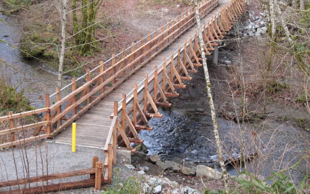
The rail trail is known as the Cowichan Valley Trail, which is the Cowichan Valley Regional District’s contribution to the Trans Canada Trail along with the Cowichan River Park section makes for a spectacular multi-use trail and an integral part of the TCT route on Southern Vancouver Island. Between Lake Cowichan and the Kinsol Trestle, the trail follows the gentle grade of the former turn of the century CN and CP railway lines that served pioneer logging and settlement communities.
Note that through the Cowichan River Provincial Park, walkers have the option of taking the footpath that connects with the rail grade from time to time (the brown track on the map gives the approximate location of the pathway).
A step-by-step pdf description

This unforgettable hike along the Pacific Coast is somewhat rugged in places. It allows for shorter less rugged by-passes (magenta track) that miss the truly iconic viewpoints that have viewing platforms. It is a trail that is still in progress with the eventual goal of joining up with the Pacific Rim National Park with its magnificent sandy beaches. This trail is quite a contrast to Long Beach showing off the ruggedness of the Pacific Coast with the sea ravaging its rock cliffs and its effects on the vegetation. There are opportunities to go on the beach when the tide is out or heading out when on the lighthouse part of the trail. Allow about 3 hours to explore the whole trail. Go to this website for a brochure about the trail.
This quite challenging loop includes the Brentwood-Mill Bay Crossing, the Kinsol Trestle and the full length of Shawnigan Lake for about a 86 km not counting the 5.5 km Brentwood Crossing (total 92 km). What a great loop this is for hardy cross-country cyclists; especially the new trail between Langford and the east end of the rail trail along Shawnigan Lake being by far the toughest section.
The regional districts have done a super job creating new trail sections to a high standard. It is the number and length of the steep grades that make it challenging. The hope is that when the new surface hardens and all the surfacing is completed that the hardship will be reduced somewhat. Two of us did this on lightly loaded hybrid bikes and I lost track of how many times I got off my bike – my partner did quite a bit better than I did.
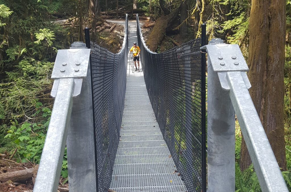
There is great bridging on this trail including a 132 foot suspension bridge – width 3’9” with 6’ high fencing giving the appearance of a very narrow feature bridge. The new Sooke Hills Wilderness Park Trail runs for 13 km from Humpback Reservoir to the CVRD Boundary on trail and service roads in the CRD Watershed climbing 350 metres between the low point at Waugh Creek and the high point on Goldstream Heights. It is another 4.6 km between here and the Galloping Goose Trail. The Cowichan Valley new Trail 8.8 km section is a heavily undulated well built trail as it reaches the rail trail above Shawnigan Lake. The total length of the new trail from the Galloping Goose to the rail trail above Shawnigan Lake is 26.5 km.
Nanaimo has succeeded in connecting several greenways to make up the Trans Canada Trail. Those walking should take the Abyss Trail between Extension and Nanaimo proper for a better experience. The main highlights are Extension itself, the parks and greenways, Buttertubs Marsh, Bowen Park, and the Nanaimo Waterfront.
It is 31k without the loop around Duncan. The actual TCT route for this leg is 28.2k needing a connector to Duncan City Center. This is a highly developed enjoyable trail that goes through a major bog and heritage sites. Close to town is the Cowichan Commons Mall, a good place to park. However, it really worthwhile to go into Duncan Centre to appreciate both Native and local heritage. The loop around town is an opportunity to follow a series of greenways that surrounds Duncan. There is more description of the sites on the Trails BC Website that describes the full Cowichan Valley Loop.

Recent Comments