The Dewdney Trail is a historic hiking/equestrian trail that follows the route used by miners and settlers in mid-19th century British Columbia. However, only a few sections of the trail remain in operation as recreational trails, including this short portion between Santa Rosa Road (Christina Lake) and Highway 22 (Rossland), which is registered as a non-motorized recreational trail by the BC Ministry of Forests (MFLNRO, Recreation Sites and Trails BC Branch). This portion of the Dewdney is 37.5 km in length and generally is an overnight hike.
Note: Our GPS tracks for the Dewdney Trail are not considered to be 100% accurate. Use at your own risk. You will notice up to three separate GPS tracks braiding along the Dewdney trail on our map; they are all from separate sources – and we have posted all three, not really knowing which (if any) are the most accurate. One is from the Ministry of Forests, while another is from OpenStreetMaps (an open source online map). A third that travels just the eastern 1/3 of the trail is supplied by the Kootenay Columbia Trails Society. We welcome your feedback – and invite anyone to send us their own GPS tracks to help us improve the accuracy. Again, please note that all tracks are “use at your own risk” (see our Disclaimer above for more details).
The Dewdney Trail is crossed many times along its length by its successor, the Cascade Highway, which was opened in 1922 and allowed travellers to drive motor vehicles over the Monashee Mountains. This gravel roadway has been largely replaced by the Crowsnest Highway, so is mainly used by recreational users – and makes a suitable route for adventure cyclists or support vehicles (4WD recommended) for hikers. It is a 72 km drive with countless hairpin turns and stunning views – but is known to be quite dry and dusty, so carry plenty of water. Our GPS track should be completely accurate.
Staging Areas:
There is parking available where Santa Rosa Road intersects the Trans Canada Trail above Christina Lake on the western end.
GPS INFORMATION:
KML/KMZ files can be opened in Google Earth, and many smartphone apps.
GPX files can be opened by most GPS software apps when KMZ cannot. Note, GPX files do not contain custom colours and icons that we use on our maps; all tracks and icons will appear the same colour and styles. We recommend using KMZ instead of GPX if possible.
The files below include data for only this specific area. For all of our Trans Canada Trail data for the entire province (including features, campsites and alternate routes), download our BC.kmz master file (1.2 MB) Visit our GPS & Navigation page for instructions of how to use your smartphone as a GPS device (even when outside of data coverage) or how to import data to your Garmin unit.
There is parking available where Santa Rosa Road intersects the Trans Canada Trail above Christina Lake on the western end.
Washrooms:
Route Highlights:
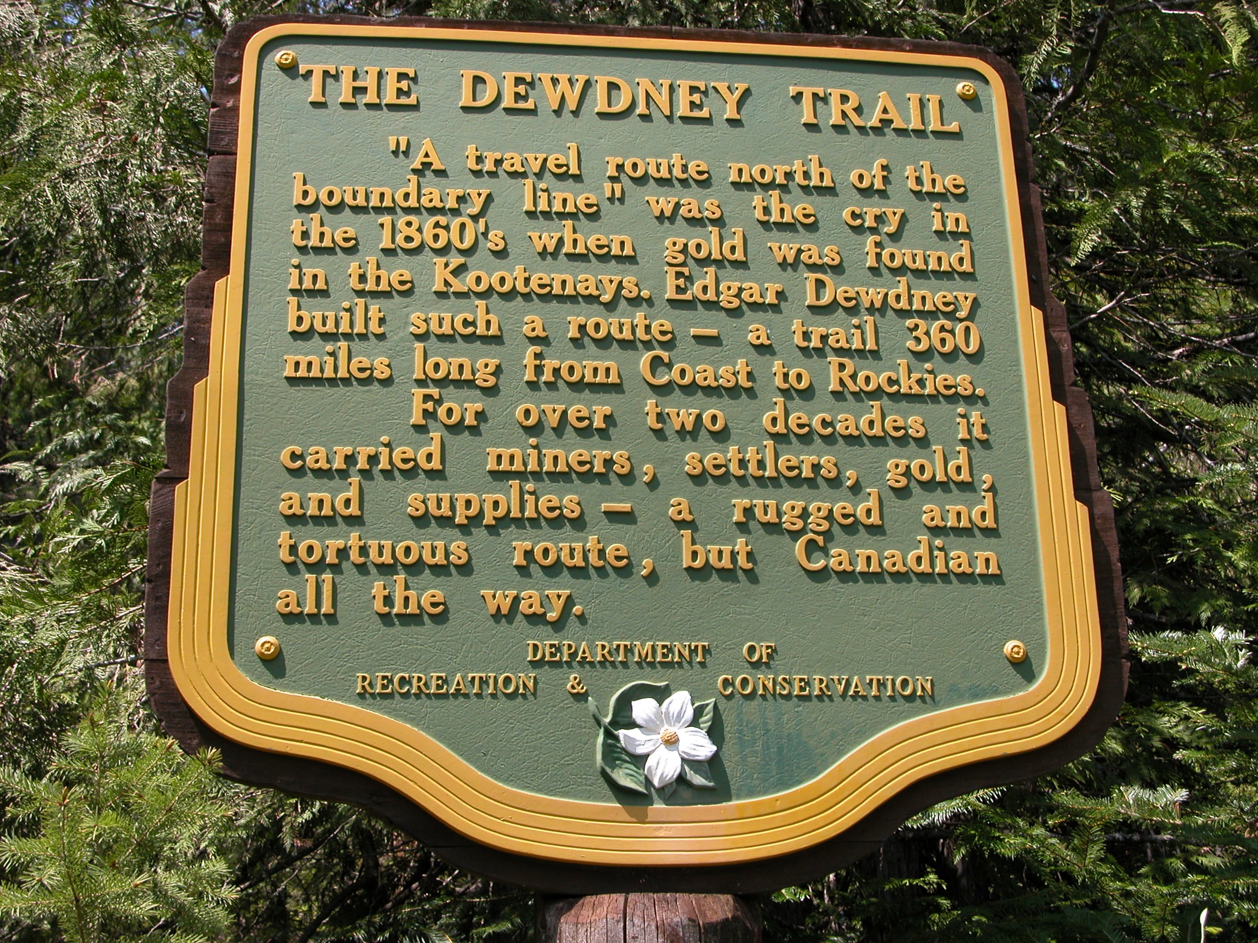
The Dewdney Trail was originally a 720 km (450 mi) trail that served as a major thoroughfare in mid-19th century British Columbia, running from Hope to Fort Steele. The trail was a critical factor in the development and strengthening of the newly established British Colony of British Columbia, tying together mining camps and small towns that were springing up along the route during the gold rush era prior to the colony’s joining Canadian Confederation in 1871. The route’s importance and urgency was prompted because many new gold finds were occurring at locations near the US border that were much more easily accessed from Washington Territory than via any practicable route from the barely settled parts of the Lower Mainland and Cariboo. Today, approximately 80 percent of the former trail has been incorporated into the Crowsnest Highway – the portion running between Christina Lake and Rossland is one of the last sections remaining in operation, though as a recreation trail.
There are no supplies or provisions along the Dewdney or Cascade. Shop for supplies on the western end in Grand Forks. Limited provisions are available in Christina Lake. Rossland and Trail are good places to provision on the eastern end.
Accomodations:
There are two campsites located on the trail – the first at Trout Creek at the 9.7 km mark, and the second at the Santa Rosa Recreation Site at the 22.1 km mark – located 300 metres off the trail.
Transportation:
Related Links:
Tourism Rossland (tourism information available for Dewdney and Cascade routes)