The Trans Canada Trail splits in the city of Castlegar; while the main route travels east from the Brilliant Suspension Bridge towards Nelson along the Kootenay River, the traditional route runs south towards the city of Trail. This latter portion of the Trans Canada Trail could be described as a spur – it does not continue further than Trail in this direction.
From the Brilliant Suspension Bridge the route follows existing trails along the riverbank through Selkirk College and under the Kinnaird Bridge. Roadways through Ootischenia are necessary in order to connect with the Columbia River Trail which begins near the old settlement of Blagodatnoye. Keep in mind that the Columbia River Trail passes through some private property – stay on the trail and leave no trace!
The Columbia River Trail – and even some sections from Castlegar to Ootischenia – is moderately challenging for touring cyclists lugging trailers or carrying panniers. Consider an alternate route using roadways. That said, there are no major obstacles – but several narrow sections and steep climbs/descents.
Spring flooding can be an issue along this entire route in early summer.
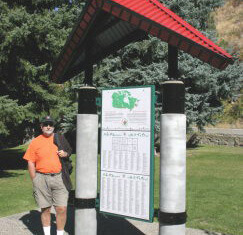
Closer to the city of Trail, the route run through Sunningdale and East Trail. A Trans Canada Trail pavilion is located in Gyro Park.
Staging Areas:
Parking is available at Gyro Park.
GPS INFORMATION:
KML/KMZ files can be opened in Google Earth, and many smartphone apps.
GPX files can be opened by most GPS software apps when KMZ cannot. Note, GPX files do not contain custom colours and icons that we use on our maps; all tracks and icons will appear the same colour and styles. We recommend using KMZ instead of GPX if possible.
The files below include data for only this specific area. For all of our Trans Canada Trail data for the entire province (including features, campsites and alternate routes), download our BC.kmz master file (1.2 MB)
Visit our GPS & Navigation page for instructions of how to use your smartphone as a GPS device (even when outside of data coverage) or how to import data to your Garmin unit.
Fantastic views of the Columbia River from Gyro Park
Hiking and Mountain Biking trail options abound! Check the Kootenay Columbia Trails Society’s site for details
Be sure to check out the remains of the Blagodatnoye settlement and its orchards at the north end of the Columbia River Trail.
The trail route will be improved and extended into downtown Trail once a pedestrian bridge is constructed over the Columbia River.
Also, a connector trail to the city of Rossland using former rail grade exists; please see our map for more details (see the “Alternate Trails” layer). From Rossland, one can continue west to Christina Lake using the Dewdney Trail (hiking and equestrian friendly) or the old Cascade Highway (rugged, but bicycle-friendly).
For the section of Trans Canada Trail (Sunningdale in the north to East Trail in the south) from Sunningdale into the city of Trail:
From the water tower above Sunningdale, the trail follows the gravel service road. When reaching Marianna Crescent, turn right (SW) towards the river. Marianna becomes Hazelwood Drive. Continue along Hazelwood to the end, where it meets Hillside – the road becomes Charles Lakes Drive. A trail on the right (SW) side runs along the river, at the same elevation as the road. This paved trail is in perfect shape and provides views of the river below. At Gyro Park, you will find the Trans Canada Trail Pavilion. The trail will continue through the park, remaining parallel to the river, before ending at an unnamed road (essentially a back alleyway). Turn right onto the road, following it until the road ends and a trail runs under the highway bridge. The trail currently terminates at the future site of a pedestrian bridge (yet to be constructed) that will cross the Columbia River and arrive in downtown Trail.