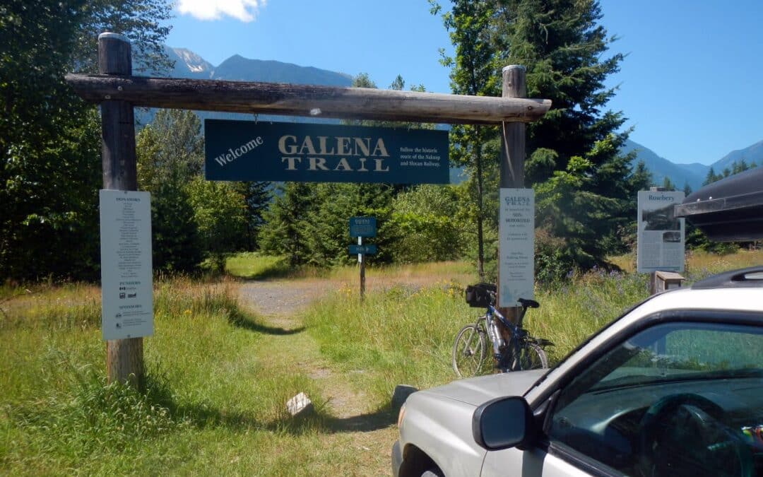
The Nakusp & Slocan (N&S) Railway and Galena Trail combine to create a continuous trail between Nakusp (in the northwest) to Three Forks east of New Denver. The northwestern portion from Summit Lake to Nakusp is reported to be well maintained by the Nakusp and Area Community Trails Society. The section between Summit Lake and Rosebery is reported to have overgrowth and is subject to water issues in Spring to early Summer. Expect motorized use on these sections. The popular 14-15 km Galena Trail starting at Rosebery West of New Denver to Three Forks, is a designated non-motorized greenway and is well managed by the Regional District. It features a cable car that allows users to cross Carpenter Creek near Three Forks.
Heading further east you can try to follow the Kaslo River Trailway, an abandoned rail corridor between Kalso and Three Forks. Some of the railways has been converted to trail, while other sections are now forestry road, and some have been abandoned. Our map shows an approximation of the route – and should be used with a high degree of caution and scepticism! If you have an updated GPS track for us to use, please submit it to us! We have included a road route which should be the route used when in doubt.
When combined, the entire corridor (including road connections) is approximately 94 kilometres between Nakusp and Kaslo.

The Vancouver Island Spine Trail is a 700-km proposed wilderness trail that will run from tip-to-tip along the spine of Vancouver Island. The goal of the Vancouver Island Spine Trail Association (VISTA) is to utilize as many existing trails as possible, but they are building new connector trails each summer. There are ample opportunities to volunteer for trail building sessions – please visit their web site for more details.
Since we do not host or update this trail map, we do not offer a GPS download for this trail. Please download the latest copy by opening this map in Google Maps and selecting “Download KML” from the menu.
Note: The map above has been created by VISTA and will automatically update as they make changes to their routes. We cannot guarantee the accuracy of the data! Although some sections of the Spine Trail are complete and operational, many parts are not. Contact VISTA for the latest trail maps and conditions.
The Howe Sound Crest Trail is a fantastic, but challenging 28 km hiking journey along mountaintops north of Vancouver between Cypress Mountain and Porteau Cove. The hike provides view of Howe Sound from dizzying heights, but the hike itself isn’t exceptionally technical or dangerous – though some parts can be quite intimidating. Normally, this hike is undertaken as an overnight trip by staying at one of the campsites along the way – the Magnesia Meadows campsite being a suitable halfway mark.
The route connects to the Trans Canada Trail in West Vancouver – and many hikers begin the trip at this intersection, located at the parking lot of the Cypress Mountain ski hill. The northern terminus is located at Highway 99 near Porteau Cove. Unfortunately, public transit from this point does not exist so most hikers are reliant on a pick-up.

This 39 km loop takes in the incredible scenery of Victoria’s south-facing shoreline through the James Bay, Fairfield, and Gonzales neighborhoods, before swinging northeast, passing by Oak Bay’s marina, Willows Beach, the Royal Victoria Yacht Club, and through Saanich’s Cadboro Bay village. The route turns north and rounds the top of Mount Douglas Park on Royal Oak before joining the Lochside trail – a perfect route that connects with the Galloping Goose trail and returns to downtown Victoria.
Please note that the majority of this ride (excluding Lochside and Galloping Goose trails) is on roads. Although there are few bike lanes, this is a popular and safe ride for road-savvy cyclists.
This hike in Strathcona Provincial Park features the highest falls in Canada (444 metres/1456 ft.); they are spectacular and a must see destination. It is a 15-km hike to the base of the falls with another hike of nearly 3 km to a viewpoint on the Love Lake-Mount Septimus Trail.
The trailhead is accessed by boat, kayak, or canoe from one end of Grand Central Lake requiring a 33 km trip, the other end of the lake. Many choose to use the shuttle service (see Highlights below).
For those arriving by canoe, there are a few informal campsites along the lake. Scout Beach is a popular recreational site and possible place to launch a canoe (while cutting down on distance to paddle to the Della Falls trailhead). Most suitable camping areas are roughly 3/4 of the way to the Della Falls trailhead along the north shore. There is a rack for kayaks and canoes at the trailhead.
The main camps are at the trailhead, Margaret Creek (6.7 km), and near Della Falls (14.2/14.7 km). There is wilderness camping (12.2 km) on a small beach along Drinkwater Creek.
The main trail follows Drinkwater Creek named after a gold prospector who worked this area in 1899. The first 10 km is essentially a rail grade interrupted by creek washouts and water damage causing many detours and walking on slippery rocks crossing creeks. There is frequent water damage on the trail. Bridging at Margaret Creek for example is higher up the creek for an easier crossing but creating quite a climb and descent. There are usually quite a few tree falls requiring ducking under, detouring, or climbing over. The trail is also overgrown in places. From the cable bridge it becomes a rugged single track trail and a bit difficult to follow in spots especially the section just past the wilderness camp where the trail heads over large rocks that are part of an old rock fall from the high cliffs looming above. Flagging is in place for wayfinding. There are many pleasant sections overall and the tree cover is much appreciated for much of the hike.
The falls are at their best in mid July when glacial run off is at its peak. However, visitors in mid-August will find swimming in Love Lake to be much more comfortable!
Mud isn’t a huge issue, but gaitors can come in handy due to thorny bushes that you may encounter on the trail.

Recent Comments