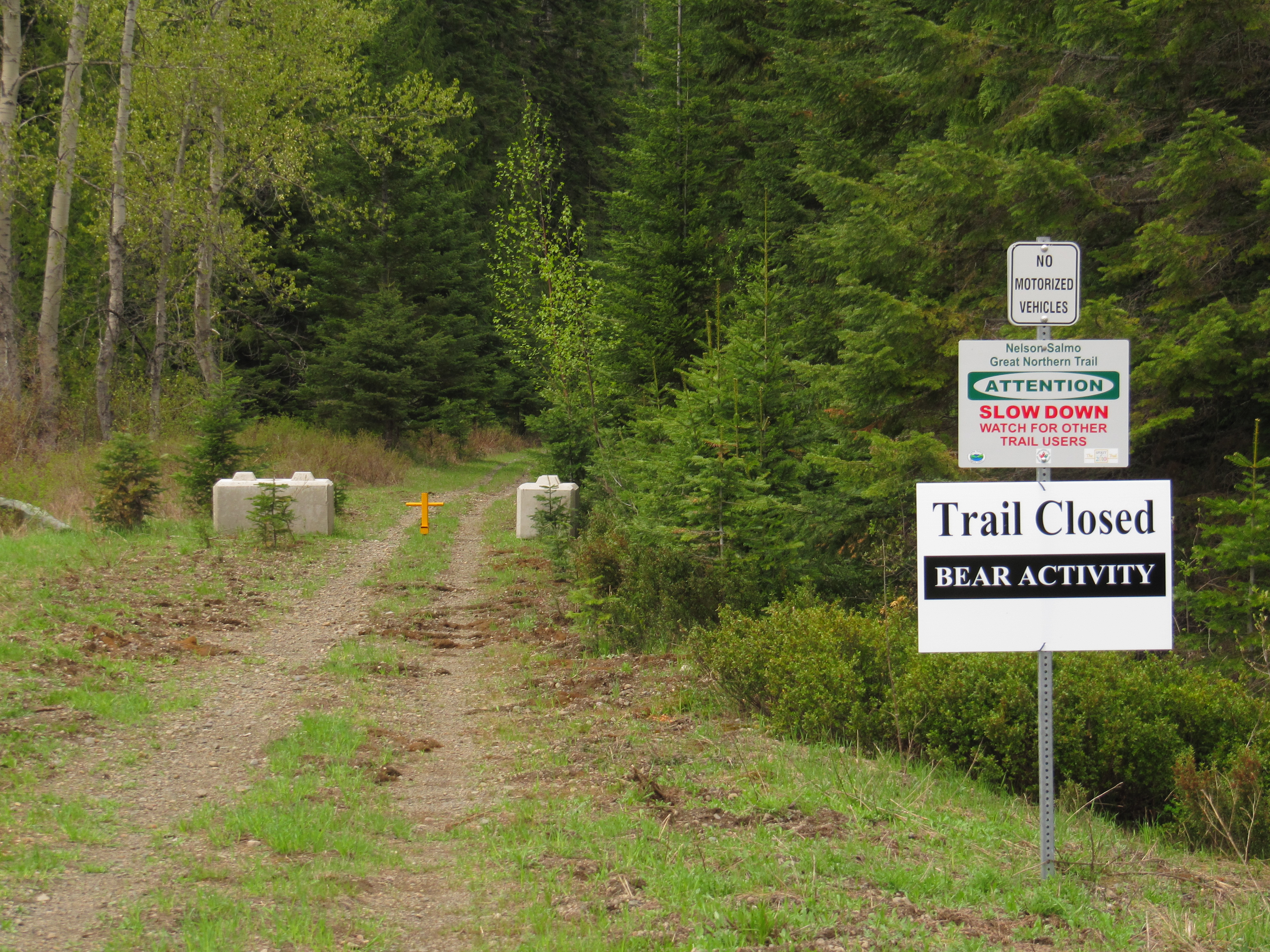
Ongoing, originally posted in 2013 -- Notice affecting the Salmo Area -- Annual closure in effect April 15 to June 15 (approx) -- Due to grizzly bear foraging each spring, the Salmo Great Northern rail trail is normally closed annually for 10 kilometres between Cottonwood Lake and Hall Siding (northern section, about 8 km south of Nelson) from mid April to mid June. The trail operator, the Regional District of Central Kootenay (RDCK), is responsible for this closure. Users are asked to use the highway as a bypass route when the closure is in effect. Read more on the Regional District's trail page. Note, the RDCK rarely (if ever) updates this webpage . Signs are posted along the trail when the closure is in effect, but the only other way to know if the closure is in effect is by contacting the RDCK directly; call their main switchboard at (250) 352-6665.
The Salmo Great Northern Trail is a 48 km abandoned railway running between the town of Salmo in the south, and the city of Nelson in the north. The railway was operated by Burlington Northern Santa Fe. Today, most trail stewardship is overseen by the Regional District of Central Kootenay (RDCK).
The trail’s gravel surface is highly degraded in the Salmo area, but improves as the trail heads north, away from heavy motorized activity. The RDCK allows motorized use on the trail’s southern half from Salmo to roughly Hall Siding, though off-highway vehicles currently cannot legally cross highways (as of Winter 2014), the damage by motorized vehicles typically tapers off at the first highway crossing north of Salmo.
The river valley can be quiet and falling trees are sometimes an issue. We encourage eager trail users to consider carrying a small hand saw to take care of trail blockages – trimming back a few branches will allow cyclists and hikers to pass through easier. The trail normally improves in quality as it approaches Mountain Station, above Nelson.
Please note: The Regional District of Central Kootenay is initiating an annual spring trail closure for a portion of the Nelson-Salmo Great Northern Trail. The annual closure will include the trail south of Cottonwood Lake parking area to Hall Siding. The closure is in effect each year from May 1st until June 15th. Signs will be posted accordingly at the entrance to trail closures. Collared bear data has shown the area from Cottonwood Lake to Hall siding, particularly the areas of Apex and Camp Busk, are heavily used by grizzly bears in the spring. The bears use this area because of its high valued forage habitat. In most cases the bears move on to higher elevations by the middle of June. It is felt that an annual closure will help ensure public safety and benefit the local bear population from over exposure.
As black bear and grizzly bear activity is common in the Spring and early Summer, bears may be present on the trail system throughout the year so please remember to always:
use caution;
do not attempt to view or approach bears;
do not leave garbage or food on trails
Please respect all closures. Thank you for your cooperation!
Staging Areas:
GPS INFORMATION:
KML/KMZ files can be opened in Google Earth, and many smartphone apps.
GPX files can be opened by most GPS software apps when KMZ cannot. Note, GPX files do not contain custom colours and icons that we use on our maps; all tracks and icons will appear the same colour and styles. We recommend using KMZ instead of GPX if possible.
The files below include data for only this specific area. For all of our Trans Canada Trail data for the entire province (including features, campsites and alternate routes), download our BC.kmz master file (1.2 MB)
Visit our GPS & Navigation page for instructions of how to use your smartphone as a GPS device (even when outside of data coverage) or how to import data to your Garmin unit.
Railway history c/o Spirit of 2010 Trail web site: The rail line was built by American Daniel Corbin. His Spokane Falls and Northern (SF&N) Railway reached navigable water on the Columbia River only 24 kilometres south of the Canada/US border in 1890. Corbin continued building his railroad north, and completed the Nelson and Fort Sheppard (N&FS) Railway in 1893, providing Nelson with an uninterrupted rail line to Spokane, Washington. Another significant step in railway expansion was the opening of the Great Northern Railway main line from Spokane to Seattle, also in 1893. The rail line was initially forced to use ‘Mountain Station’, located high above Nelson, with a steamer dock at Troup, British Columbia 8 kilometres north east of the ‘Queen City’ on Kootenay Lake. In 1895 a rail loop was established at Troup with a line along the lake to the outskirts of a neighbourhood called ‘Bogustown’ just outside of Nelson, now known as the Fairview neighbourhood.
In 1898 Great Northern Railway acquired a controlling interest in both SF&N and N&FS railways and two years later, acquired running rights to the new CPR station in Nelson. Great Northern Railway purchased SF&N outright in 1907 and the N&FS in 1944 and merged into the Burlington Northern System in 1970.
In the early days, the rail line formed an important connection for the West Kootenay mining towns, allowing efficient shipping of their rich ores to the United States. Passenger traffic also flowed between Nelson and Spokane from 1893 to 1941. All train traffic into the region ceased in 1989 (though the Waneta section continued for a while longer). In 1998 the rails and ties were removed between Ross Spur and Salmo, and in 1999 the final removal of the rails and ties between Salmo and Troup was completed.