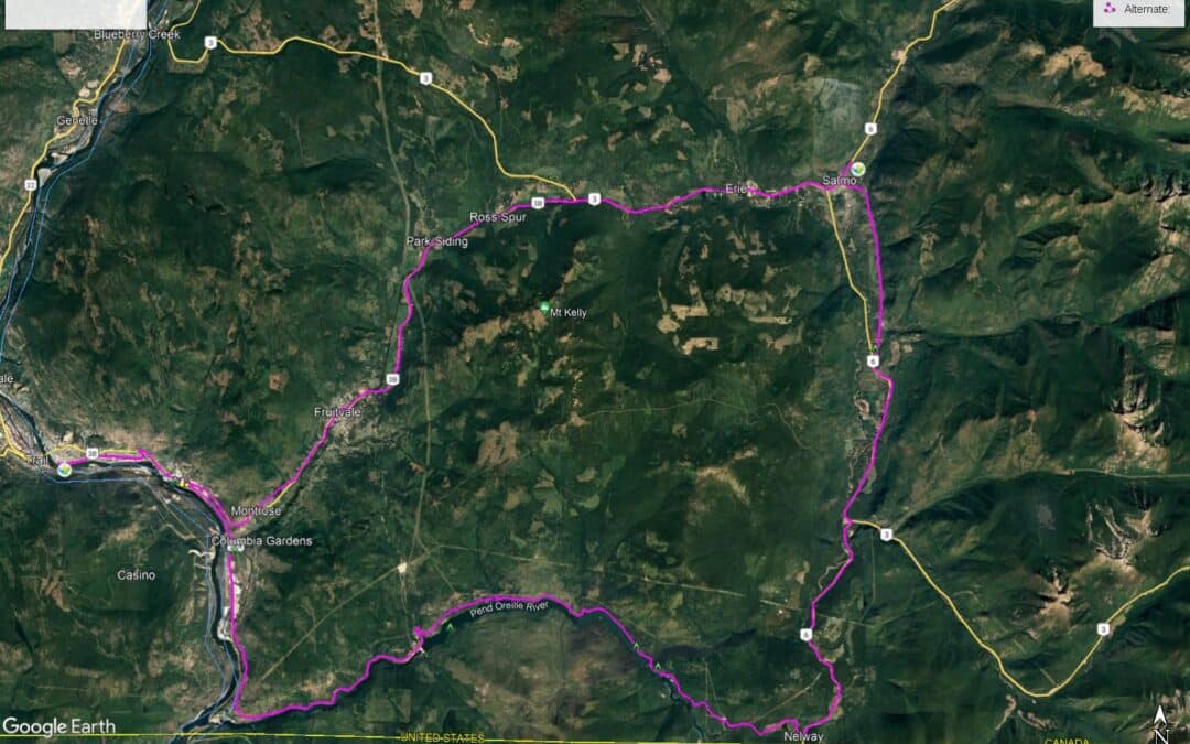
The route between Trail and Salmo is not part of the Trans Canada Trail. However, for those travelling from Castlegar south to Trail, the two routes described here will allow one to connect to the southern terminus of the Salmo Great Northern Railway for a pleasant ride north to Nelson. This can be a suitable route for bicyclists who have chosen not to take the “main route” of the Trans Canada Trail from Castlegar directly to Nelson via the Skattebo Reach and Ward’s Ferry Trail, both of which are unsuitable (and not permitted) for cyclists at this time.
Our two favoured alternate routes connecting Trail and Salmo are either A) Following Highway 3B through the Beaver Valley via Montrose and Fruitvale, or B) taking a journey further south to the Pend Oreille River, then returning north again from Nelway to Salmo on Highway 6. Much of this route is on unpaved roadways.
For those travelling to Salmo via the Beaver Valley, the route leaving Trail on Highway 3B begins with a long climb up the mountainside to Montrose and Fruitvale – however, it is the only substantial hill on the route. The rest of the highway to Salmo is otherwise fairly flat and simple to follow.
The Pend Oreille is a quieter and longer route. It can be quite hot and dusty at times, but it surely a more memorable adventure.
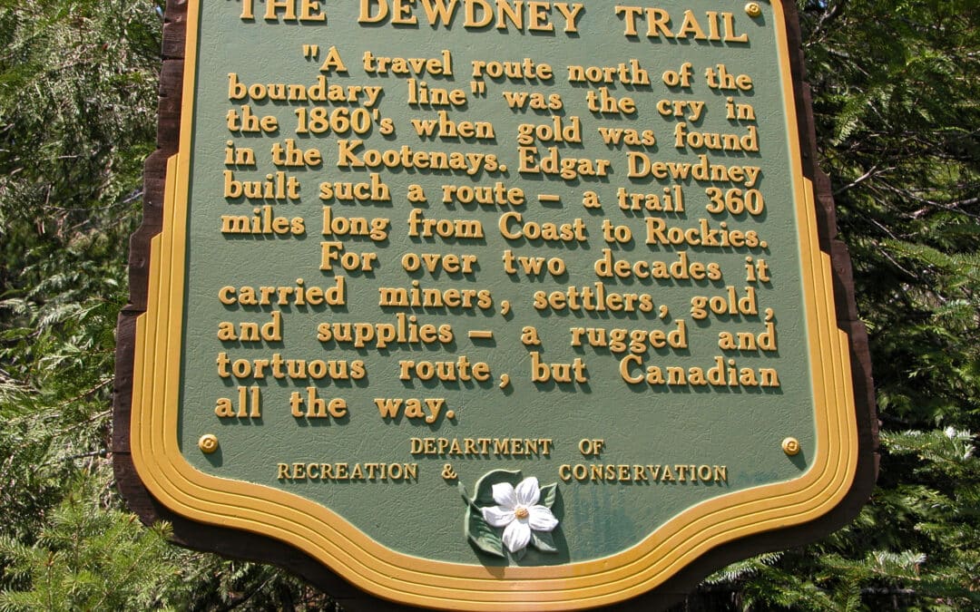
The Dewdney Trail is a historic hiking/equestrian trail that follows the route used by miners and settlers in mid-19th century British Columbia. However, only a few sections of the trail remain in operation as recreational trails, including this short portion between Santa Rosa Road (Christina Lake) and Highway 22 (Rossland), which is registered as a non-motorized recreational trail by the BC Ministry of Forests (MFLNRO, Recreation Sites and Trails BC Branch). This portion of the Dewdney is 37.5 km in length and generally is an overnight hike.
Note: Our GPS tracks for the Dewdney Trail are not considered to be 100% accurate. Use at your own risk. You will notice up to three separate GPS tracks braiding along the Dewdney trail on our map; they are all from separate sources – and we have posted all three, not really knowing which (if any) are the most accurate. One is from the Ministry of Forests, while another is from OpenStreetMaps (an open source online map). A third that travels just the eastern 1/3 of the trail is supplied by the Kootenay Columbia Trails Society. We welcome your feedback – and invite anyone to send us their own GPS tracks to help us improve the accuracy. Again, please note that all tracks are “use at your own risk” (see our Disclaimer above for more details).
The Dewdney Trail is crossed many times along its length by its successor, the Cascade Highway, which was opened in 1922 and allowed travellers to drive motor vehicles over the Monashee Mountains. This gravel roadway has been largely replaced by the Crowsnest Highway, so is mainly used by recreational users – and makes a suitable route for adventure cyclists or support vehicles (4WD recommended) for hikers. It is a 72 km drive with countless hairpin turns and stunning views – but is known to be quite dry and dusty, so carry plenty of water. Our GPS track should be completely accurate.
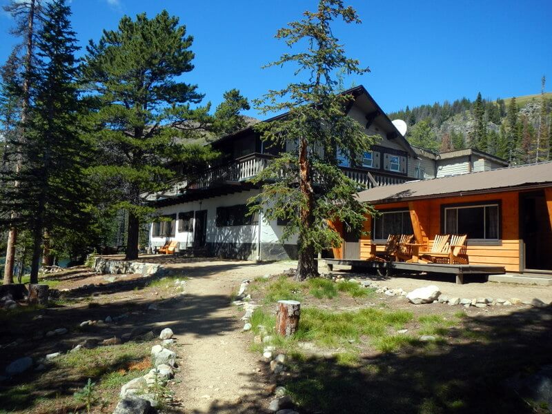
The extraordinary Cathedral Provincial Park owes its name to sensational mountain peaks that reach over 2600m/8,500 ft around a bowl in the Cascade Mountains just north of the U.S.A. border.
The majority of people visit the park by either camping or booking a room at the Cathedral Lakes Provincial Lodge. In either case, the best way to access the area is by booking a shuttle with the lodge.
Suggested time: 2 half days and 2 full days (3 nights) allowing to arrive on the 10:00 a.m. shuttle and leaving on the 3:00 p.m. shuttle.
The general location of the park is 22 km out of Keremeos on the south side of the Similkameen River. Here it is as described in Wikipedia:
Cathedral Provincial Park and Protected Area, usually known as Cathedral Provincial Park and also as Cathedral Park, is a provincial park in British Columbia, Canada. It is located east of E.C. Manning Provincial Park, south of BC Highway 3, and southeast of the town of Princeton and southwest of Keremeos. Its southern boundary is the border with the United States. Much of the park is the basin of the Ashnola River.
Suggested Hiking Itinerary
Diamond Loop (including Scout Lake) – half day (following the 10:00 a.m. shuttle – 8.8 km counter clockwise
Rim Trail Loop via Diamond Trail Loop junction, to Red Mt, Quiniscoe Mt, Pyramid Mt., Devils Wood Pile, Smokey the Bear/Giant Cleft, Lady Slipper Lake and back to Lodge- Full day about 7.5 to 8.5 hrs (counter clockwise) – 16 km
Goat Lake via Box Car Mt. and Lakeview Mtn. Loop – Full Day – approx. 14 km (optional – if staying for 2 nights only you may wish to forego this hike.
Lake of the Woods, Pyramid Lake, Glacier Lake and Quiniscoe Lake (including falls) Loops – half day, 8-km – clockwise – take the 3:00 p.m. shuttle out
The complete Centennial Trail through the Park is much longer as is the trail taking in Haystack Mt. These are multi-day back packing hikes.


Recent Comments