
This 16.2 km loop can be cycled or walked, taking in the well maintained and paved Rotary Trail, then following enjoyable dirt trails in the local Community Forest. In the Community Forest the Juniper Lane and Isadore Connector trails are used. Just over half of this loop route is already designated as part of the Trans Canada Trail.
- Walking time roughly 4 hours. Also suitable for jogging but be mindful at street crossings.
- Cycling time roughly 1 hour.
- Horses are not permitted on the paved Rotary Way but are welcome in the Community Forest.
- No stairs or accessibility issues, though some sections have rough surfaces.
- Rollerblading and skateboarding are not recommended.
Take note: At the northernmost point of the route, where the Isadore Rail Trail and the Community Forest intersect, the route is quite steep (average 10% grade), heading uphill (east) into the Community Forest. Therefore, cyclists travelling in a clockwise fashion on the loop may have to push their bikes for up to 1 km. We highly recommend using this route in a counter-clockwise direction.. unless you’re craving a good hill climb!

The Arrow Lakes are divided into Upper Arrow Lake and Lower Arrow Lake, are widenings of the Columbia River. The lakes are situated between the Selkirk Mountains to the east and the Monashee Mountains to the west. Beachland is fairly rare, and is interspersed with rocky headlands and steep cliffs. Mountain sides are heavily forested, and rise sharply to elevations around 2,600 metres.
The original routing and descriptions were produced by Kelly Kusch for the Nakusp Paddling Club Society. Trails BC has been given permission to post this route, but users should review the original guide, available on the Paddling Club’s website
Note: This is merely a guide for information purposes. The Nakusp Paddling Club Society is not responsible for the safety or activity of lake users, and does not warrant the complete accuracy of this document.
If you would like to help us improve our mapping and populate this page with more information about paddling in this area, please contact Trails BC.
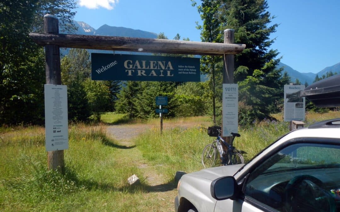
The Nakusp & Slocan (N&S) Railway and Galena Trail combine to create a continuous trail between Nakusp (in the northwest) to Three Forks east of New Denver. The northwestern portion from Summit Lake to Nakusp is reported to be well maintained by the Nakusp and Area Community Trails Society. The section between Summit Lake and Rosebery is reported to have overgrowth and is subject to water issues in Spring to early Summer. Expect motorized use on these sections. The popular 14-15 km Galena Trail starting at Rosebery West of New Denver to Three Forks, is a designated non-motorized greenway and is well managed by the Regional District. It features a cable car that allows users to cross Carpenter Creek near Three Forks.
Heading further east you can try to follow the Kaslo River Trailway, an abandoned rail corridor between Kalso and Three Forks. Some of the railways has been converted to trail, while other sections are now forestry road, and some have been abandoned. Our map shows an approximation of the route – and should be used with a high degree of caution and scepticism! If you have an updated GPS track for us to use, please submit it to us! We have included a road route which should be the route used when in doubt.
When combined, the entire corridor (including road connections) is approximately 94 kilometres between Nakusp and Kaslo.

The Trans Canada Trail splits in the city of Castlegar; while the main route travels east from the Brilliant Suspension Bridge towards Nelson along the Kootenay River, the traditional route runs south towards the city of Trail. This latter portion of the Trans Canada Trail could be described as a spur – it does not continue further than Trail in this direction.
From the Brilliant Suspension Bridge the route follows existing trails along the riverbank through Selkirk College and under the Kinnaird Bridge. Roadways through Ootischenia are necessary in order to connect with the Columbia River Trail which begins near the old settlement of Blagodatnoye. Keep in mind that the Columbia River Trail passes through some private property – stay on the trail and leave no trace!
The Columbia River Trail – and even some sections from Castlegar to Ootischenia – is moderately challenging for touring cyclists lugging trailers or carrying panniers. Consider an alternate route using roadways. That said, there are no major obstacles – but several narrow sections and steep climbs/descents.
Spring flooding can be an issue along this entire route in early summer.
Closer to the city of Trail, the route run through Sunningdale and East Trail. A Trans Canada Trail pavilion is located in Gyro Park.

The Trans Canada Trail from Fernie to Elkford is mostly suited to mountain bikers and hikers, with winding narrow trails making up a great deal of the distance. However, bypass routes for touring cyclists do exist.
Within Fernie, an older “legacy” portion of the trail runs counter-clockwise around the west and north circumference of the city, along the Elk River. This section of the trail is splendid and easy for cyclists and walkers alike. Northbound (Sparwood) bound touring cyclists may wish to leave the trail at the NW corner, using the highway bridge to cross the river and begin travelling north; this will bypass the more difficult section of the Elk Valley Trail between Fernie and Hosmer.
For those continuing on the official trail route, the “legacy” route rejoins the Elk Valley Trail at the Eastern side of the town’s circumference. Alternatively, the Elk Valley Trail can simply be travelled directly north from the Aquatic Centre. Leaving the city headed north, the “Elk Valley Trail” (formerly known as the Coal Discovery Trail) travels north to Hosmer – a fantastic novice mountain bike and hiking trail. From Hosmer north to Ingham (a reference to the nearby highway rest area, as the area doesn’t seem to have an actual official name), the official route leaves the Elk Valley Trail and follows the highway for a short time in order to bypass a section that is not designated as part of the Trans Canada Trail due to wildlife concerns. The trail is indeed open to the public however, so users may continue north on the trail if they wish.
The highway bypass does reconnect with the Elk Valley Trail and leads to the Mountain Shadow campground, through the golf course, crossing the highway and entering Sparwood by the Titan truck, before continuing north towards Elkford.
New sections of trail reduce the number of kilometres one must travel along Highway 43 (Elk Valley Highway) and Lower Elk Valley Road between Sparwood and Elkford.

Recent Comments